 Add Row
  Add
Add 


Revolutionizing Mars Exploration with Innovation
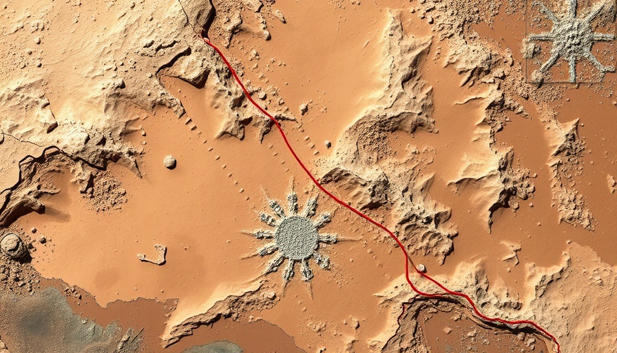
The recent advancements in visual localization and topographic mapping employed by the Zhurong rover mark a significant leap in our capabilities to explore Mars. The collaborative effort from researchers at the Aerospace Information Research Institute, part of the Chinese Academy of Sciences, showcases how technological prowess can improve the efficiency of interplanetary exploration. By honing in on visual localization techniques, the Zhurong rover can navigate the treacherous Martian terrain with much greater accuracy than previously possible.
The Importance of Accurate Navigation Systems
As part of China's Tianwen-1 mission, launched in July 2020, Zhurong, which landed in Utopia Planitia on May 22, 2021, relies on high-resolution topographic mapping to guide its movements and scientific investigations. The rover has traveled a distance of over 2,000 meters, revealing the necessity of precision in localization systems to accommodate for obstacles associated with the Martian landscape. The 3D maps created through advancements in camera and sensor technologies enable the rover to avoid pitfalls and errors inherent in onboard systems.
Innovative Techniques for Enhanced Image Quality
Recent enhancements to Zhurong’s navigation system include vignette correction and online camera mast calibration techniques, which have transformed image quality captured by its Navigation and Terrain Cameras. These innovations are critical for generating detailed three-dimensional representations of Mars's surface, allowing researchers to not only guide the rover effectively but also dive deeper into analyzing geological features such as aeolian ridges and impact craters. These insights aid in unraveling the planet's geological history and climate trends, which is pivotal for future exploratory missions.
Looking Ahead: What these Developments Mean for Future Mars Missions
These technological advances lay a cornerstone for future exploration efforts, not just for China but for the global community engaged in Martian research. The ability to create accurate terrain maps and effectively navigate complex landscapes will inform designs of next-generation rovers and landers. Collaboration among international space agencies could yield significant insights that further our understanding of Martian geology, potentially uncovering signs of past life or resources that could support human missions. As we push further into Mars exploration, the groundwork laid by Zhurong's mission will surely inspire and guide complex interplanetary projects in the years to come.
Concluding Thoughts: The Impact of Localized Understanding on Space Exploration
In essence, the enhancements made to Zhurong rover's navigation denote a paradigm shift in our approach to space exploration. By embracing innovative methodologies in visual localization and topographic mapping, we not only ensure more successful exploratory missions but also advance our foundational understanding of other planets. As countries around the world look towards Mars, understanding the intricacies of its surface will be essential. The success of missions like Tianwen-1 will pave the way for human exploration, making it imperative to invest in technology that sharpens our ability to map and navigate extraterrestrial environments effectively.


Write A Comment